


Hiking in Oberstaufen

Hiking in Oberstaufen
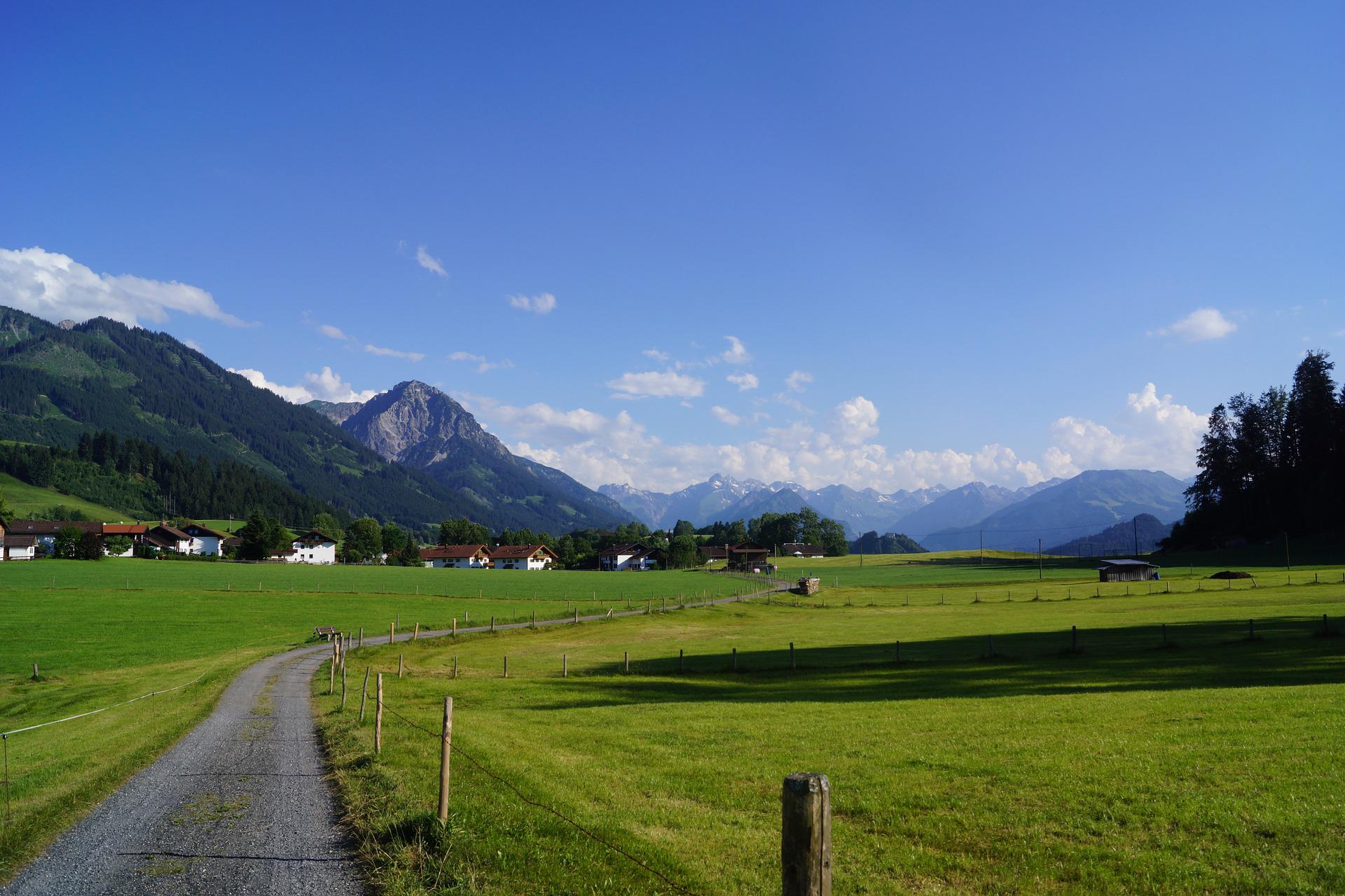
Nowhere else will you get a better impression of impressive nature and vastness than when hiking in the Allgäu mountains. Breathe in the fresh mountain air and enjoy the unlimited views in the Allgäu hiking paradise of Oberstaufen.
The mountains are calling for you! The Oberstaufen region and its surroundings are a true hiking paradise. Adventurous hikes of all levels of difficulty await you on over 350 kilometers of hiking trails. With its varied network of hiking trails, Oberstaufen is perfect for a hiking holiday in the Allgäu.

Hiking with the whole family
Experienced hikers will enjoy climbing to the summit on hikes and mountain hikes. Beginners and families enjoy hiking on adventure trails, easy hikes or guided tours. Oberstaufen is an excellent hiking destination with its beautiful hiking trails. If you are planning a real hiking holiday, explore the Allgäu mountains around Oberstaufen with multi-day hikes and the hiking trilogy.
We have listed 15 exciting hiking routes in Oberstaufen for you:
1. Steibis-Buchenegger waterfalls
The hike takes you from Steibis via the Neugreuther Alm to the Buchenegger waterfalls, where the water falls down to a depth of up to 18 m and in summer invites you to take a swim in the 18°C cold water. The waterfalls are part of the Allgäu Geopark.

We first drive towards the village center and dairy. There we turn towards Achrain, which leads directly to Christl-Cranz-Weg. On this road we pass the first clearing. After a piece of forest remains behind us, we turn left at the next intersection. Alpe Neugreuth is now in front of us. Here we can take a break before continuing to the waterfalls. An impressive sight awaits us here, as the water falls up to 18 m deep in places and in midsummer it is perfect for swimming.
We return through the Neugschwend meadows, up the "gable" to the Berggasthof Hirsch. At the inn we turn left onto a path that initially runs parallel to the main path. After about 500 m our path turns left and finally leads to the street “In der Au”. We pass a farm on the right and reach a T-junction. To return, take the left path and turn right immediately after the intersection. This route automatically takes you to Steibis, where you can take the bus back to Oberstaufen train station.
2. Kapellenweg 5
From our starting point, the Tourist Information Center in the center of Steibis, follow the road “Am Gemsholz” in a southwesterly direction until you reach the turnoff to Bärenloch-Alpe. Here follow the signs to the right and continue climbing until you finally reach a small road. Follow this road west to Hagspiel.

At the end of the village you will see the beautiful chapel of St. Nicholas de Flue. Cross the road towards the chapel and follow the road until you reach a junction with a footpath. Follow the signs via Dreiländerblick in the direction of Schindelberg to the Rochus Chapel. In Schindelberg you walk briefly uphill on a small road and then turn left to return to Steibis with the parish church of the Transfiguration of Christ Steibis.
Alternative: From Hagspiel, walk along the street and cross the "Nägeleshalde" to Aach. A visit to the parish church of Maria imSchnee is recommended. From here there is a bus connection to Oberstaufen and Steibis.
3. Airy Ridge" premium alpine hiking trail
The airy ridge leads into the Alpine world and to the most beautiful views of the Nagelfluhkette Nature Park. This hike requires good fitness and experience in the mountains.

After climbing the mountain with the Hochgrat cable car, the trail begins at 1.708 m and leads to Porta Alpinae. We continue along the western Nagelfluh chain past the Seelekopf, Hohenfluhalpkopf and Eineguntkopf. On this alpine section you need sure-footedness and a head for heights. Above the Falkenhütte you leave the ridge and after crossing a plane tree garden and descending again, you reach Lanzenbach. Cross the metal bridge on the south side and climb over Alpe Remmelegg to the end of the route at the mountain station of the Imbergbahn.
On the ridge above the Falkenhütte, a panoramic plateau invites you to take a break. On clear days, the view to the west reveals a breathtaking panorama: from the neighboring Bregenzerwald mountains to the impressive Säntis massif in Switzerland, from Lake Constance with its vineyards and orchards to the milk and cheese paradise of Upper Swabia and the western Allgäu. Sometimes the view in the distance even extends as far as the Swabian Alb.
The Nagelfluhkette is a world of its own. It is the habitat for many protected animals and plants. Alpine ravens, crows, golden eagles and black grouse live here, as do many young cattle in the mountain summer. Many alpine huts have been set up and invite you to stop by.
4. Premium hiking trail Alpine Freedom
This path takes you through an area that is one of the largest contiguous alpine areas in Bavaria. Here you can experience the diverse and valuable cultural landscape of the Allgäu up close.

From the mountain station of the Imbergbahn, go south down to the Lanzenbach and climb on the opposite side via the Mittelstieg to the Oberstiegalpe. Staying at this height, you cross the slope to the Hörmoos area with its lake circular path. Shortly afterwards you cross the Austrian border.
At the Hoch Häderich valley station, the path leads over the Häderichmoor to Moosalpe, where it follows the path west to the Kojenstein viewpoint. We continue along the Stone Gate over the mountain ridge to Fluh and back to the starting point at the mountain station of the Imbergbahn.
Immediately after the Oberstiegalpe the path leads into a real plane tree garden. There are many of these strange trees, including an impressive "hollow tree". The Häderichmoor on the way back is one of the best-preserved raised bogs at this altitude. From the Kojenstein viewing mountain, the view extends in all directions to Lake Constance. There are many places where you can stop and refresh yourself.
5. To the Eibele waterfalls
Hike south through a nature park to the border village of Eibele. A visit to the Eibele waterfalls is highly recommended. Through the Weißachtal back to Oberstaufen.

Follow Schlossstrasse and Bergstrasse to the intersection with the B308. Here you turn left into the underpass onto Willisstraße. Keep left and pass the hunting area below the Hotel Berkristall on the beautiful road to Hinterhalden. After you have passed the Ponyhof, you will reach the Eibele district.
Cross this to the wooden bridge on the border with Vorarlberg. To the right of the bridge is the Eibele waterfall - the short detour is worth it. To get to the Krebs waterfall, walk back a few meters on the road and reach the Weißach dam at the end of the village.
Turn left here and follow the asphalted road on the left side of the Weißach upstream to the district of Weißach. Just before you reach the village, turn left and walk through the quarry up to the Malas Holiday Club. On the other side of the road you can return to Oberstaufen via the Aurel-Stadler-Weg.
6. Kapellenweg 8
Leave the train station in a westerly direction via Bahnhofstrasse and continue along Hugo-von-Königsegg-Strasse, past the Catholic parish church and over Montfortweg to the Protestant church and the senior center.

Cross the green area and go up the Mount of Olives Chapel, following the Stations of the Cross until you reach the street. Follow the road to the right until you reach a signpost for Kapf. Continue towards Berg and Laufenegg, leaving the chapel on the right side of the road. Cross under the B 308 and drive west through Döbelisried, following the signs to Eibele.
Turn left towards the bridge over the Weißach with the Krebs waterfall. The road continues to the right on a gravel path, then on a cycle and footpath to the district of Aach with the parish church of Maria im Schnee. Now climb up, initially on the path, until you reach the edge of the forest.
Here turn right onto the path and then back onto the road to Hagspiel. If you St. When you reach Nikolaus von Flüe, turn left onto the Dreiländerblick in the direction of Schindelberg with the Rochus Chapel and Steibis with the parish church. From the village center follow the signs to the Buchenegg waterfall.
After a steep climb you reach a gravel road. Turn left onto the road heading west until you reach the village of Buchenegg with its Lady Chapel. In the village, turn right again and follow the signs to the Hündlebahn mountain station.
Continue walking east and enjoying the beautiful views until the path meets a small paved road. Turn right and follow the small street. Just before the end, turn left off the road and follow the signs first down and then east to Sämelalpweg.
Follow this road into the valley floor. Follow the community road on the left side west towards Osterdorf and Thalkirchdorf with its parish church, or you will reach the Konstanz Chapel on the right side of the community road. Alternatively, follow the valley floor from Thalkirchdorf to Wiedemannsdorf. Follow the signs north again along the railway line to the west. Here you can head towards St. Georgs Chapel in Knechtenhofen.
Drive through the Wengen district towards Kalzhofen with the Maria Immaculata chapel near the St. Georgen. In town, turn right onto Meeraustraße, past the Hotel Haubers Gutshof in the direction of Schwarzenbachtal. You drive past the golf course, through the forest and reach the beautiful Bartholomew Chapel in Zell.
We follow the road to Buflings, cross the state road and follow the path to Oberstaufen. After the railway bridge we turn left and walk along the railway line to the starting point of our tour, the Oberstaufen train station.
7. Show distillery “Zur Höll”
"Zur Höll", a show distillery in the Weissacher Valley, is our destination. The starting point for this hike is the Rosenalp, from where you hike towards the Kurpark via the Panoramaweg - from which you have a wonderful view of Oberstaufen - to the Stießberg. Before the B308, follow the signs “Zur Höll” to the left and cross under the main road. A little caution is required as the ground is somewhat steep. When the weather is clear you have an excellent view of the Säntis. Continue down to Willis and Eibele.
Below the Hotel Bergkristall you will pass a hunting area with deer and their ladies. At the signpost, turn left into the forest.Before the wooden bridge, keep left and walk calmly through Weissach to our destination “Zur Höll”. Follow the signs On the way back to the Enzianhütte, turn left via Malas, section "Aurel-Stadler-Weg" back to Oberstaufen.
8. From Oberstaufen to the Eibele waterfalls - Westallgäu waterway 23
From the parking lot the path climbs and runs parallel to the German Via Alpina to the subway. On the other side of the road the path continues to Willis, where a small nature park is ideal for a visit, especially for families with children. The road leads past Halden and Hinterhalden to Eibele. Continue straight until you reach the wooden border bridge at the end of the village. A few meters further on the right side, the Eibelebach flows down a few steps and flows into a large pond.
The gravel bank opposite invites you to play and explore. The path continues to the Krebs reservoir, where the water from the Weißach is dammed to generate energy. Today the Krebs Waterfall hardly flows anymore. A look into the depths shows the power that the water has unleashed here over the past millennia: the water has carved mighty gorges, smooth channels and deep, swirling holes in the hard rock. Finally the path leads back to Oberstaufen via Halden, Weißach and Malas.
9. From Aubachtal to Siplingerkopf and back via Heidenkopf and Girenkopf
From the Aubachtal car park, first cross the stream and follow the signs to Siplinger Kopf. The route winds through the forest along a fascinating gorge to Siplinger Alp. We head across alpine pastures to Siplinger Nadel, a small, free-standing peak. The path then leads over numerous steps along the mountain ridge to the summit cross. The path from Siplinger Kopf to Heidenkopf always leads along the ridge, which becomes quite narrow in some places.
It leads down over a short, steep rock face (secured with ropes) and over another short rock face secured with ropes. From the summit of Heidenkopf you can shorten your route and follow the path down to Alpe Scheidwang. However, our route continues over the ridge to the Girenkopf. There is also a short, steep section on this trail that is safe. The summit cross of the Girenkopf is not that easy to find.
It is located on a small hill a little below the highest point. On the way down, go back a few meters until the ridge makes a noticeable curve. Shortly before that, a “tube” leads us to the cirque. Through steep meadows we reach the Scheidwanger Melke area, where we find the hiking trail again. If visibility is good, orientation is not difficult. After a short walk through the forest we reach the Scheidwanger Alm. From here an asphalt road takes us back to our starting point.
10. Mountain and water experience Prodel
An exciting circular route through the mountain range between Prodel and Denneberg with wonderful panoramic views. A unique natural spectacle awaits hikers at the Buchenegg waterfalls.

After the Hochgrat cable car, cross the bridge over the Weißach and continue hiking down into the valley to the next junction. On the right side a beautiful path leads to Prodel-Alpe. At the junction, follow the path along the upper slope in an easterly direction through the Prodel to the Denneberg summit.
Shortly before the summit, take the path that leads steeply to the left down to the Prodel ski lift station. Via the upper and lower Mittelbergalpe you reach the Moosalpe (refreshments available) on an alpine path. We continue through the Foxholes over the Ochsenschwand and the Tura Alps down to the entrance to the Buchenegg Falls. A steep path leads to an impressive gorge - safety for pedestrians is important here.
On the other side of the Weißach the path climbs again. Follow the signs for the Allgäu hiking trilogy and you will soon reach the Weißach downhill a second time. Cross the so-called Tarzansteg on the other side of the Weißach and climb the well-known Hochgratweg.
11. Return hike to Salmaser Höhe
A fairly varied route from Oberstaufen to Kalzhofer and then on to Salmaser Höhe with beautiful panoramic views in all directions. On the south side to Thalkirchdorf and in the valley to Oberstaufen.

From the train station go east towards Kalzhofen. At the northern end of the village, turn right and follow the Alpine road past the golf courses to the Obere Gsäng Alpe. Here you go straight up the meadow path, keep right at the summit and follow the ridge eastwards to Kalzhofener Höhe. Here you descend to an alpine path and follow it to the left until you reach a sharp bend. Go straight ahead and keep right at the next intersection. The path then leads left over a small gully and through meadows to a road. Turn right uphill, past the Hirnbein-Alm (open in summer) to Salmaser Höhe (highest point on the hike with a wonderful view). Here you follow the signs to Thaler Höhe for a while, then turn right along Schneiders Alpe to Schneidberg Alpe, where there is a farm.
Continue on the Fortstweg to Wiedemannsdorf, where you turn right at the railway crossing and cross the railway tracks on the hiking trail along Lamprechts and Salmas to the foot of the Staufen. Turn right onto the path through a mixed forest to Wengener Stadelstraße and return to Oberstaufen.
12. Panorama route through the Nagelfluh-West mountain range
This route offers a lot of variety and several opportunities to stop off. The section on the ridge between Hoch Häderich and Falkenköpfe is secured with ropes and requires mountain experience, sure-footedness and a head for heights.

Take the cable car to Imberg. From the mountain station, follow the alpine path to the Berggasthof Hochbühl (refreshments available) and further down to Lanzenbach. From there you climb up to the Hörmoos mountain inn (refreshments available) and continue along the mountain path to the Falkenhütte until you turn right towards Falken halfway down the path. The path soon leads west along the ridge above the Falkenköpfe to the summit of Hoch Häderich. This section is partially secured with steel cables and requires head and foot protection at height.
13. Hochsiedelrunde
A varied forest and meadow path with wonderful views of the Konstanz valley and the Alpsee.

From the Hündlebahn valley station, follow the path up to the mountain station. Walk past the Hündle dairy to the next junction. Take the path to the Hündle summit and enjoy the fantastic panoramic views. Follow the meadow path to the east and continue on the gravel path past the Hochsiedel lift station to the Hochsiedel-Alm. Here you follow the valley path through the forest to the Schwändle mountain inn (refreshments available).
Alternatively, you can also continue on the mountain path to Moosalpe and from there on the mountain path to Schwändle. Follow the road downhill to the sawmill. Here you turn left and pass the Thalkirchdorf ski lift. Along the Konstanzer Aach you return to the Hündle car park.
14. Circular hike Oberstaufen-Eibele-Aach
The hike on the German-Austrian border takes you on an 11 km long route below the "paradise" of Oberstaufen. We stop at the pony farm in Hinterhalden and hike to the Eibele holiday village, where we start our return journey via the Weißachtalweg. In Weißach we have the option of taking the bus back to Oberstaufen, but we can also take the route via Malas.

We start at the Hotel Rosenalp and immediately turn right. At the bend in Paul-Rieder-Straße, take the stairs down to Isnyer Straße. Turn left onto Rothenfelsstrasse. At the end of Rothenfelsstrasse turn right, then immediately left and shortly afterwards right into Schloßstrasse. Follow Schloßstraße, then Bergstraße, which leads to the B308. The next road takes us to the village of Willis, which we cross on the main road and reach via Hinterhalden.
Refreshment awaits us at the pony farm, and then we make our way to Eibele. Here we are halfway down the road. Turn left onto Eibelestrasse. The path now takes you closer to the flowing Weißach. The path follows the slope to Vorderhalden. After the farm we come to a bridge that we do not cross. Turn left just before the bridge and you will automatically come to Höfen vor Weißach. Here you can decide whether you want to walk to Oberstaufen and cross Malas, or whether you want to take route 29 or 31 to Oberstaufen train station.
If you choose the sporty option, turn off at the left fork of our hiking trail in Höfen and go straight to Malas. We then follow the path that runs parallel to the road. Finally we go under the B308 and back to the hotel via the train station.
15. Hündle-Schwändle adventure trail
From the hotel we walk through Hinterstaufen to the valley station of the Hündle cable car. From there, take the chairlift or walk to the upper cable car station. The picturesque Hündle adventure trail begins at this station. It is a circular route with numerous information boards, which first leads past the Obere Hündle dairy and the Hochsiedel dairy, then through the forest back to the Hündle mountain station. Take the familiar route back to the cable car valley station and return by bus or on foot.

The starting point of our hike is the Hotel Rosenalp. First walk along the street “Am Lohacker” until you reach Mayor-Hertlein-Straße, where you turn left. The street will soon become Mayor-Ucherer-Straße. At the next intersection keep left and follow Immenstädter Straße to the end of the village. Pass the Stehle nursery and, behind the last houses, take the meadow path to Hinterstaufen.
Drive clockwise through the shady forests around Staufner Berg. After turning left at the junction to Hinterstaufen, continue straight ahead. Cross the Immenstadt-Oberstaufen railway line and keep left just behind the tracks. At the next fork in the road, take the right alternative, which takes you via an underpass to the other side of the B308. After you have passed the parking lot on the right, you will reach the valley station of the Hündle cable car.
If you want to shorten your route, you can take the chairlift to the mountain station. Alternatively, walk along the cable car building and follow the wide alpine path to the Hündle mountain station. The path winds up to the right of the summer toboggan run. The Hündle Panorama Trail begins at the mountain station, where the Hündle mountain restaurant invites you to stop off. First follow the signs east to Obere Hündle Alpe. In the alpine cheese dairy we learn interesting facts about cheese production. We leave the alpine house behind us and follow the alpine path through the pastures further east to Alpe Hochsiedel.
On the information boards along the way we learn, among other things, about the formation of the Allgäu Alps. At the southern exit of Hochsiedel-Alpe, take the path to the left that leads you towards Schwand-Alpe. You will reach a gravel road through the forest where you turn left. The path on the right leads to Schwand-Alpe.
On the way you will be explained the different plants and herbs that grow here. On the forest path that we now follow, we learn interesting facts about the mixed forest, the Ice Age and the animals of the forest. We can also try out what different types of wood sound like or what the earth feels like when we walk barefoot. At the intersection where the Alpine road leads left to the Hündle mountain station, we keep right and descend on the gravel road, which we already know from the climb to the valley station of the Hündle cable car. From there you take the bus back to Oberstaufen or hike through Hinterstaufen to the Hotel Rosenalp.


